Whether determining the location of one asset relative to another or identifying the geographic coordinates of a feature on the Earth, geospatial professionals are focused on identifying where things are. Accurate location data enables land surveyors, construction foremen, engineers, and others to take precise measurements of features and assets that have value to them. Transportation engineers want to measure distances between features along a corridor, mine and landfill managers need to calculate volumes of materials, and environmental managers may measure the area of a hazardous impact zone. Whatever you are trying to measure or locate, you will need to select the right perspective and tool to acquire the data.
Terrestrial & Aerial Maps : two different perspectives
There are two perspectives from which geospatial intelligence is typically collected; terrestrial data is collected from the ground and aerial data is collected from the air above the Earth’s surface. Determining whether to collect terrestrial or aerial data is largely a question of scale. The required accuracy and other project specifications, such as the types of data deliverables needed, are generally another large factor in determining the method and perspective used to collect geospatial data.
Mapping features over a small area might be conducted quite efficiently from the ground while, for example, creating an elevation model of a large area can be quite cumbersome or unprecise when done from the ground. Terrestrial data is highly valuable when seeking a precise location of a small-scale object, taking accurate vertical locations for a topographic survey over a limited area, measuring vertical surfaces such as facades of buildings, or locating features under infrastructure or heavy vegetation. Many professional devices and instruments exist for this sort of data collection such as GNSS rovers, total stations, and terrestrial laser scanners. Such equipment and their associated work flows can produce highly accurate surface models, point location datasets, and derived deliverables such as contours, cross sections, and cut/fill calculations.
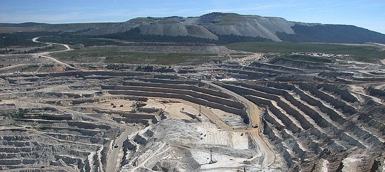
Projects of a medium- to large-scale are generally better served by aerial data collection. From the air, the perspective of an instrument directed down toward the Earth’s surface offers the ability to detect features that cannot be seen from the ground below. These features can then be triangulated, located, and mapped relative to one another and relative to the Earth’s surface as a whole. There is an array of different sensor types which can acquire the aerial data including cameras that capture bands of light both visible to the human eye and not visible, such as infrared or other bands which can be meaningful in agriculture or other industries. Light detection and ranging (LiDAR) sensors are also frequently deployed which function like radar but use light from lasers to measure distances to the surface of an object. Putting these sensors in the air can enable an operator to collect data on a larger scale than what is feasible on the ground in an efficient and accurate manner.
UAV Mapping Closes the Efficiency Gap
Traditionally, these sensors have been mounted on manned aircraft, such as airplanes and helicopters, or satellites, to collect aerial imagery which can be interpreted into orthomosaic images, digital surface models, and point clouds. Remote sensing via aircraft and satellite has proven to bring tremendous value to the geospatial community and continues to do so. However, these technologies have their limitations including high mobilization costs even for small- or medium-sized projects, the inability to collect data in poor or cloudy weather conditions, lengthy turnaround times from data acquisition to data delivery, and constrained resolution and precision of the final data deliverables.
What is left is a gap in the market of geospatial data collection between the point where terrestrial methods work best and traditional aerial methods are cost-effective and efficient. Projects that are not well-suited by either terrestrial or these large-craft aerial data collection methods are still executed by one or the other. Inefficiencies, delays, budget overruns, and data that is either inadequate or overkill result.
Unmanned aircraft systems (UAS), also known as unmanned aerial vehicles (UAV) or drones, fill this gap as an efficient geospatial data collection tool positioned between terrestrial and large-craft aerial methods. Drones have proven in recent years to be a valuable tool among the geospatial community. They provide an aerial perspective, but can remain close enough to the surface to produce a tremendous level of detail. They can carry many different sensors which are capable of capturing features, assets, and patterns that may not otherwise be discovered. They can perform in adverse weather, below cloud cover, and on-demand for rapid turnaround of data that provides answers to time-sensitive questions. Finally, the affordability of drone solutions makes them accessible to any organization to use as a cost-effective tool for mapping small to large areas. Drones provide a unique, versatile perspective and are an indispensable data collection tool for the geospatial industry.