Topographic mapping is a routine task for many surveyors, engineers, and construction professionals. Just about any project design requires a topographic survey in order for a project manager to know what the characteristics of the ground are in order to properly design the project.
A topographic map is most often delivered as contours which are 2D isolines that depict the 3D shape of the Earth’s surface at a given location. These contours are used to calculate metrics such as slope, water flow, cost estimates, cut and fill (dirt to be moved from where to where), locations of undulations or hazards in the existing surface, and volumes of material. When it comes to topographic mapping, unmanned aerial vehicles (UAVs) have filled an efficiency gap in the geospatial toolbox between when it makes the most sense to use terrestrial methods such as RTK GNSS, total stations, and laser scanners, and when it makes sense to hire a manned aerial mapping service or order satellite imagery for a project.
Why Contour Interval Matters
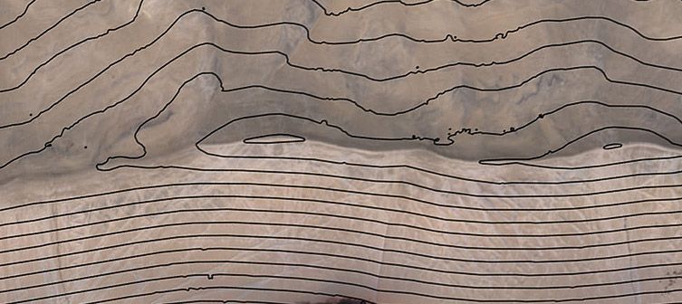
When topographic maps are generated and contours created the spacing between neighboring contour lines is defined as the contour interval. For example, a course, or large-scale (e.g. 1:24 000), contour map of many tens of square kilometers or miles might have a contour interval of 40 m. This means that the change in elevation between one contour line and the next is 40 m up or down. When it comes to civil engineering projects such as road or bridge construction, hydrologic modeling, construction site preparation, or other design projects, 40 meters is no where near precise enough of a contour interval. Having an elevation off by 40 m at a single point could mean the difference between several tons of material that needs to be moved or it could even mean a location is not suitable to build upon. Large contour intervals do not give detail as to where low spots that may accumulate water are or where slopes may be unstable and could lead to landslides. Therefore, precise topographic maps are frequently produced by collecting data in the field, often by a licensed professional land surveyor or civil engineer.
It is common for a professional topographic map of engineer-quality to have a contour interval of 50 cm (or about 2 feet in some parts of the world). This is generally sufficient for design, but many astute engineers prefer even more precision and target contour intervals of around 30 cm (1 foot). While this may not sound overly difficult, that level of precision requires even more accuracy and a very dense topographic survey. A topographic survey generally consists of many points (topo points) with horizontal and vertical coordinates (X, Y, and Z). For small contour intervals, a high-resolution topographic map must first be produced in order to model the contours. Traditional ground based RTK surveys or even satellite or aerial data from manned aircrafts may not provide a dense enough surface of points to model 30 cm contours. As a general rule, to produce accurate contours, your collection of topo points need an absolute vertical accuracy of at least half of the contour interval you wish to have. This is no small task for any tool, but drones offer the opportunity to get the high density of topo points required along with the accuracy needed for very small contour intervals.
Project size & tool selection : the expertise of the fixed-wing drones
In topographic mapping – the larger the project area, the bigger the tool and/or the more man power and time required to collect the data. Smaller project areas, such as those that range from perhaps one hectare (about 2.5 acres) to several hectares, are likely best completed with terrestrial surveying tools such as RTK GNSS equipment or total stations. For projects as much as one square kilometer (250 acres), multirotor drones are great tools which can produce very high-resolution data. However, multirotor UAVs are generally limited in endurance and airspeed which reduces the amount of area they can cover per flight. It would take multiple flights, battery swaps, and logistics to complete a 1 square kilometer aerial survey with a multirotor UAV. Manned aircraft can collect relatively high-resolution data, but the economies of scale do not really justify their use unless a project is rather large, perhaps starting around 20 square kilometers (around 8 square miles).
And therein lies the gap that professional and expert fixed-wing drones fill as an efficient and cost-effective solution for topographic mapping—projects that require high-resolution data and measure from around 1 sq km to around 20 sq km (up to about 8 sq mi). Professional fixed-wing drones provide a cost-effective way to produce accurate topographic maps with small contour intervals for the most precise project requirements of surveyors and engineers.
It is common for a professional topographic map of engineer-quality to have a contour interval of 50 cm (or about 2 feet in some parts of the world). This is generally sufficient for design, but many astute engineers prefer even more precision and target contour intervals of around 30 cm (1 foot). While this may not sound overly difficult, that level of precision requires even more accuracy and a very dense topographic survey. A topographic survey generally consists of many points (topo points) with horizontal and vertical coordinates (X, Y, and Z). For small contour intervals, a high-resolution topographic map must first be produced in order to model the contours. Traditional ground based RTK surveys or even satellite or aerial data from manned aircrafts may not provide a dense enough surface of points to model 30 cm contours. As a general rule, to produce accurate contours, your collection of topo points need an absolute vertical accuracy of at least half of the contour interval you wish to have. This is no small task for any tool, but drones offer the opportunity to get the high density of topo points required along with the accuracy needed for very small contour intervals.
Discover the UX11, a new large-scale
mapping drone for Geospatial: