Leading engineering and survey firm works with regional distributor Navigation Electronics, Inc. to select high performance drone that covers more ground, reduces costs in civil design, construction and energy projects
LOS ANGELES – October 30, 2018 – Delair a leading global supplier of commercial drone solutions, along with one of its regional resellers, Navigation Electronics, Inc (NEI), today announced that Crafton Tull, a diverse engineering and survey firm based in Conway, Arkansas, has adopted the Delair UX11 high-performance UAV for performing its work in civil and highway design and planning as well as energy surveying. Crafton Tull will initially be deploying the drone to do high accuracy mapping for an energy project involving planning of pipeline and transmission routes and surveying large parcels of land.
The Delair UX11 UAV, introduced commercially earlier this year, is one of Delair’s top-of-the-line drones. The fixed-wing drone is an innovative hardware-software platform that provides highly accurate images for survey-grade mapping, with on-board processing capabilities and real-time, long-range control. The platform’s enhanced centimeter-level precision along with its efficient operational characteristics make it the most cost-effective solution for large area surveying and mapping.
NEI worked along side Crafton Tull engineering and field experts to evaluate the Delair drone, and ensure it met Crafton Tull’s requirements.
“The Delair UX11 is a very capable and efficient platform for us to use, especially in large scale planning work. Its ability to perform long range flights and its overall endurance is a major factor in improving productivity, reducing field time and lowering costs for us, which we can then pass along to our customers” said Nick Tucker, Vice President of Energy Services at Crafton Tull. “It’s a very user friendly and mobile system, so our time from truck to flight is much faster. We also appreciate the radio range of the data link and the 3G capabilities that give us access to real time information even from great distances.”
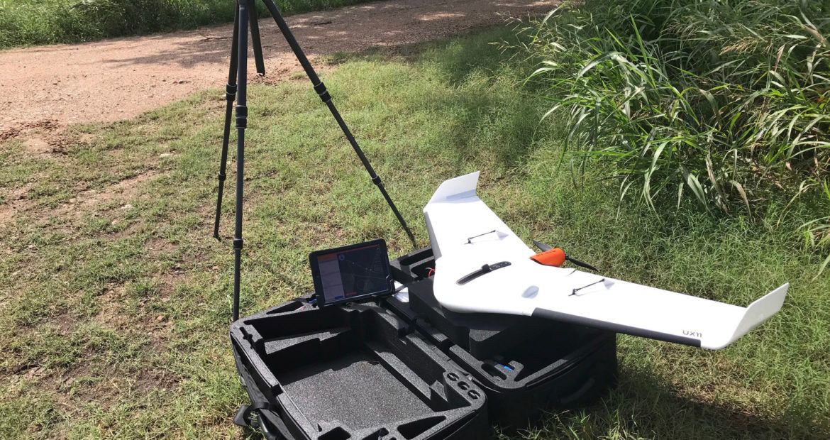
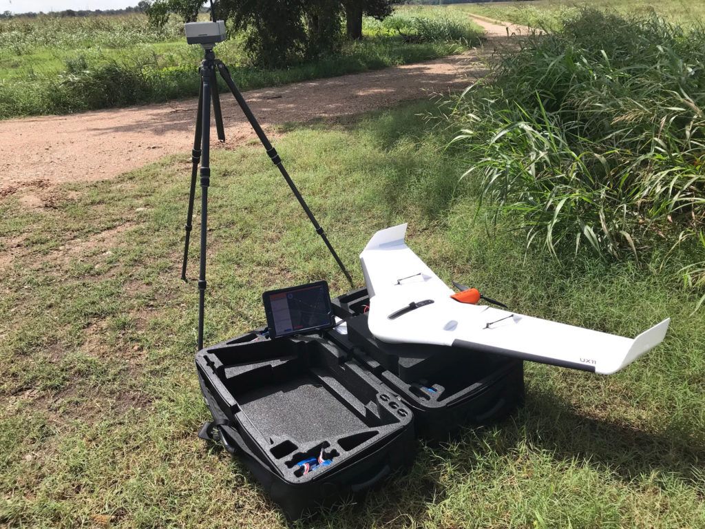
![]() Initial deployment of the Delair UX11 included a surveying mission covering a 52-mile corridor for a planned pipeline. The Crafton Tull team was able to collect high resolution and extremely accurate imagery in a single flight that otherwise would have taken multiple missions. The data can be quickly analyzed to optimize pipeline route planning, feasibility and location improvement. The solution integrates well with the existing work flow and other systems used in the firm’s planning processes.
Initial deployment of the Delair UX11 included a surveying mission covering a 52-mile corridor for a planned pipeline. The Crafton Tull team was able to collect high resolution and extremely accurate imagery in a single flight that otherwise would have taken multiple missions. The data can be quickly analyzed to optimize pipeline route planning, feasibility and location improvement. The solution integrates well with the existing work flow and other systems used in the firm’s planning processes.
The firm will also deploy the drone in civil engineering projects to aid in planning of highways, construction projects and landscape design
Crafton Tull selected the Delair UX11 after a thorough evaluation process with NEI, including on-site demonstrations and in-depth product presentations. Tucker cited NEI’s pre- and post-sales support as a key factor in the decision and early success with the Delair drone, calling NEI’s service “the best we have worked with.”
“The Delair UX11 is a complete solution that meets the requirements of Crafton Tull very well. Features like an embedded global shutter camera, intuitive analytics and data reporting tools, and post processed kinematic (PPK) capabilities for high quality results make it well suited for the accuracy and detail they need,” said William Poche, Vice President and Director of Sales at NEI. “With both 2.4 GHz wireless and 3G/4G cellular connectivity, it’s versatile from a communication standpoint, and its’ long-range operational performance significantly lowers the total cost of ownership.”
END
About Delair
Delair is a leading provider of drone-based solutions that enable enterprises to monitor and digitize their physical assets from the air and turn the collected data into valuable business insights. Its solutions are used globally by customers in industries such as utilities, construction, agriculture, transportation, mining and oil and gas. The company is one of the world’s most experienced providers of industrial drone solutions, combining its high performance, long range UAV hardware with sophisticated analytics technology and operational services. A strategic relationship with Intel and the Intel Insight Platform is driving the two companies toward designing the industry’s most scalable platform for drone imagery storage and business intelligence. Founded in 2011 by experts in the aerospace industry, the company is headquartered in Toulouse, France, and has offices in Ghent, Belgium, Los Angeles and Singapore. Its solutions are sold in more than 70 countries by a network of distributors. For more information about Delair and its brand-new generation of beyond-visual-line-of-sight (BVLOS) drones with 3G/4G communications, go to www.delair.aero and on twitter @DelairTech
About Crafton Tull
Crafton Tull is a leading and award winning civil engineering, surveying, architecture, landscape architecture, and planning firm with more than 250 employees working out of seven offices across Arkansas and Oklahoma. Crafton Tull has been contributing to the built environment for over 55 years. That longevity, coupled with investments in technologies and sustainable design practices confirms that we are well crafted to lead our industry well into the 21st century. With a focus on outstanding client service, our professionals deliver quality planning, architecture, engineering and surveying services to our clients across the country. Through the latest technology in unmanned aerial systems, our team of certified UAV pilots and land surveyors can provide a uniquely high level of efficiency. We are now able to deliver faster turn-around times and have the capability to survey up to 2,000 acres per day. For more information about Crafton Tull and our services, please visit www.craftontull.com, or follow us on Twitter @craftontull, Facebook @Crafton Tull, or Instagram @craftontull.
About NEI
NEI is a complete solution provider that sells, rents, leases, and services Mapping/GIS and Surveying/Construction equipment and technology from Trimble and other leading manufacturers, with every employee focused on delivering total customer satisfaction.
Navigation Electronics, Inc. (NEI) was formed in 1984 as a division of John Chance & Assoc., performing instrument sales and service to the offshore oil and related industries. In 1988, Charlie Poche acquired NEI and began expanding its service to land, hydrographic, geodetic surveyors, as well as GIS & Mapping professionals. In 1989, NEI was one of the first Trimble GPS distributors and soon after, it grew to become one of the largest distributors of GPS surveying and mapping equipment. NEI is also an authorized ESRI and Spectra Precision /Nikon business partner, as well as LTI, Seco, Teledyne Odom, Seafloor Systems and Pacific Crest distributor.
NEI’s corporate headquarters is located in Lafayette, LA with satellite offices in Georgia, Louisiana, Mississippi, Tennessee, Alabama, Florida and Arkansas. NEI maintains their service center and sales office at their headquarters in Lafayette, LA, and a sales office & GIS training center in Duluth, GA. NEI is a women-owned and operated business, with Barbara Poche serving as President & CEO. For more information, go to https://www.neigps.com/.