3 tips for large area UAV surveys involving multi-flight missions
Drones are an effective tool for executing topographic surveys by using cameras and photogrammetry but planning missions to map large areas can be complicated. The Delair UX11 makes large-area mission planning simple by allowing the pilot to conduct multiple flights with a single flight plan, by respecting geofences that can help keep the drone where the pilot wants it, and by warning the pilot of potential terrain hazards before even taking off.
Save time and think big for topographic surveys thanks to a fixed-wing UAV
If you use drones for mapping, one of the greatest advantages of a fixed-wing UAV compared to a multirotor system is the productivity, or size of the area you can cost-effectively map. Thanks to longer flight times and the ability to cover more ground faster, one operator can easily map 2-6 times more area in a single day with a fixed-wing UAV when compared to a multirotor UAV on a similar project. Fewer battery swaps and less time spent on pre-flight inspections, takeoffs, and landings means more time in the air and more data collected. As a result, many operators of the Delair UX11 are elated to find themselves planning mapping projects of a larger scale than they would have ever considered feasible with a drone in the past.
Tip#1: Let the app plan the large-scale drone mapping mission
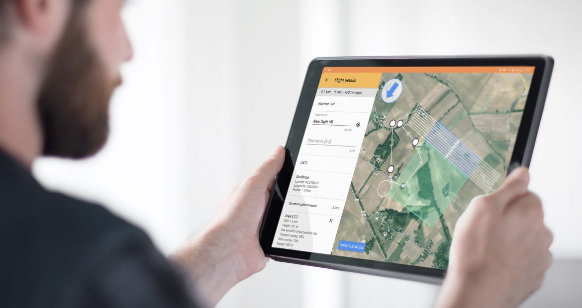
Planning large-area drone mapping missions does not come without its challenges, which is why Delair has developed Delair Flight Deck software, the Android-based mission planning application for the UX11 and UX11 Ag. Delair Flight Deck includes a specific set of features designed for professional surveyors, engineers, and UAV operators to be able to smoothly and efficiently map large sites with ease.
To get started, the operator can import a kml file of the boundary of the area they are interested in mapping, or they can digitize the area of interest in by simply tapping on the screen of the tablet to digitize the area of interest. While it is wise for an operator to keep mission sizes manageable, there is no limit to how large this area is. There is no need at this step to account for how many flights will be necessary, or even split the area up into smaller flights, Delair Flight Deck will manage that.

Once the large area of interest is created, the operator proceeds to plan the first flight by creating a flight and setting the desired parameters such as flight height (which corresponds to desired GSD or resolution), side and forward overlap, as well as takeoff and landing locations. At this stage the operator will get an estimate of how much time it will take, how many photos will be taken, and how many flights will be required to complete the mission. This can even be done from the office in order to more efficiently quote (for drone service providers) and plan a project as well as allocate the necessary resources – a great tool for those looking to bid on a project or who need to determine a budget for labor and logistics costs in advance. This can be done in only a few minutes and at this point, the mission planning is complete.
Tip#2: Leveraging geofences to make large area UAV survey mission planning easy
Geofences are user-defined areas that restrict the drone’s position to stay within a specific geographic area. A geofence is often used to avoid flying over certain areas for regulatory or safety reasons, but it can also be a handy feature when mapping large areas in order to ensure that the drone stays within visual line of sight from the operator, if that is required by local regulations.

As seen in the screenshot, the yellow polygon represents the currently activated geofence. Even though the geofence does not cover the entire area of interest for this large area mission, the geofence provides adequate coverage for the first few flights and so the pilot will be allowed to proceed with the current flight. Delair Flight Deck will notify the pilot on a flight-by-flight basis if or when the geofence is no longer sufficient for the current flight in order for the geofence to be adjusted accordingly.
Tip#3: Choose a drone that features automatic terrain following
Another useful safety feature found in Delair Flight Deck is the elevation profile. This feature allows the operator to evaluate whether there may be any terrain within the area of interest that could pose a challenge or a safety concern relative to the aircraft’s performance. The UX11 adjusts its altitude above the ground dynamically during flight in order to maintain a consistent altitude above the surface, a practice called terrain following. For big areas, you can view and analyze the elevation profile not only for the current flight, but also for the entire flight plan as seen below. This way you can be sure you have prepared a flight plan that is safe and feasible before you head to the field.
Bonus: Automatically launch drone flights one after the other
Once the pilot is ready to begin mapping, they can now proceed to the automated pre-flight checklist which will ensure that all systems are ready to fly before taking off. The flight can be conducted as normal, fully automated except for any manual interventions the pilot may conduct to maneuver the aircraft as required. The landing sequence will begin either (a) automatically once the battery level has depleted to a certain point, or (b) when the pilot decides to land by the push of a button.
Once the UX11 is safely on the ground, the pilot is given a post-flight report and is then prompted to automatically create a new flight to continue where the previous flight ended in the specified (large) area of interest. The pilot taps on a button, and is then taken to the flight screen where all the previous parameters (flight height, overlap, takeoff and landing locations, etc.) are carried over to the new flight. The battery can be swapped in under one minute, then the unit is powered-up and the pilot can initiate the pre-flight checklist again. Time on the ground is minimal allowing a pilot to get the UAV back in the air in as little as five minutes.

This process can then be repeated as many times as necessary in order to complete the entire area of interest. No complicated flight planning is required and takeoffs, landings and battery swaps are kept to a minimum. What can be extremely complicated and time-consuming both to plan and to execute with a multirotor drone or even a GNSS system on the ground can be low-hassle, simple, and efficient with the Delair UX11.